詳細検索 / Detailed search
並び順 / Sort
244,723 件中 551~600件を表示
| 大分類 / Category 資料名 / Object Name 資料番号 / Collection ID |
作者名 / Creator | 年代 / Creation Date | コレクション名 / Collections | ||
|---|---|---|---|---|---|
| 551 |

|
[文書類 / Document] 国見峠・大谷川周辺絵図 Pictorial Map |
江戸末期 19世紀 | ||
| 00002940 | |||||
| 552 |
|
[文書類 / Document] 江戸城外堀・内堀図 Pictorial Map |
武田長義/製 | 江戸後期 安永6年 1777 18世紀 | |
| 00002941 | |||||
| 553 |

|
[印刷物 / Printed Material] 最新 大東京交通地図(報知新聞第18301号附録) Latest Map of Great Tokyo Transport (Hōchi Shimbun, Vol. 18301 Supplement) |
青木武雄/編輯 | 昭和初期 昭和3年1月1日 1928 20世紀 | |
| 00002942 | |||||
| 554 |
|
[印刷物 / Printed Material] 新東京大観上巻 Panolamic View of New Tokyo, Vol. 1 |
昭和前期 昭和7年 1932 20世紀 | ||
| 00002943 | |||||
| 555 |
|
[印刷物 / Printed Material] 新日本鳥瞰図(東京朝日新聞第12351号附録) New Bird's-eye View of Japan (Tokyo Asahi Shimbun, Vol. 12351 Supplement) |
小倉検司/編輯 伊部直光/校閲 | 大正期 大正9年11月3日 1920 20世紀 | |
| 00002945 | |||||
| 556 |
|
[印刷物 / Printed Material] 全国鉄道壱萬哩記念大日本交通全図(東京日日新聞第17351号附録) Complete Map of Transportation in Japan in Commemoration of 10,000 Ri of National Railroads (Tokyo Nichi Nichi Shimbun, Vol. 17351 Supplement) |
木崎龍尾/製図彫刻 鉄道省/校閲 | 大正期 大正14年1月1日 1925 20世紀 | |
| 00002946 | |||||
| 557 |
|
[印刷物 / Printed Material] 大日本新名勝遊覧地図(東京日日新聞第19533号附録) Map of Great Japan, New Scenic Beauty Spots (Tokyo Nichi Nichi Shimbun, Vol. 19533 Supplement) |
田中孫六/製図 | 昭和初期 昭和6年1月1日 1931 20世紀 | |
| 00002947 | |||||
| 558 |
|
[印刷物 / Printed Material] 最新 大日本鉄道地図(東京日日新聞第19270号附録) Latest Railway Map of Great Japan (Tokyo Nichi Nichi Shimbun, Vol. 19270 Supplement) |
昭和初期 昭和5年1月1日 1930 20世紀 | ||
| 00002948 | |||||
| 559 |
|
[印刷物 / Printed Material] 最新 大日本地図(キング第9巻第4号附録) Latest Map of Great Japan (King, Vol. 9, No. 4 Supplement) |
森芳雄/彫刻 小川彦平/量□ 淵田忠良/編輯 | 昭和前期 昭和8年4月1日 1933 20世紀 | |
| 00002949 | |||||
| 560 |
|
[印刷物 / Printed Material] 新潟案内 Niigata Guide |
新潟商工会議所調査課/著作者 | 昭和前期 昭和8年5月20日 1933 20世紀 | |
| 00002950 | |||||
| 561 |
|
[印刷物 / Printed Material] 国際港新潟 International Niigata Port |
新潟港振興会/著作 | 昭和前期 昭和8年4月5日 1933 20世紀 | |
| 00002951 | |||||
| 562 |
|
[印刷物 / Printed Material] 新潟県の物産案内 Guide to Produce of Niigata |
新潟県物産紹介所/製作 | 昭和前期 昭和8年 1933 20世紀 | |
| 00002952 | |||||
| 563 |
|
[印刷物 / Printed Material] [横浜付近図](時事新報第16891号附録) Picture of Yokohama and Surrounding Area (Jiji Shimpō Vol. 16891 Supplement) |
昭和初期 昭和5年3月11日 1930 20世紀 | ||
| 00002953 | |||||
| 564 |
|
[印刷物 / Printed Material] 名古屋付近交通地図(扶桑新聞第8890号附録) Transport Map of Nagoya and Surrounding Areas (Fusō Shimbun, Vol. 8890 Supplement) |
豊田半之助/編輯 | 大正期 大正4年1月1日 1915 20世紀 | |
| 00002954 | |||||
| 565 |
|
[印刷物 / Printed Material] 京都府滋賀県両管内交通地図(大阪毎日新聞第九千五百四十二号付録) Traffic Map of Areas under the Jurisdiction of Kyotofu and Shigaken (Osaka Mainichi Shimbun Vol. 9542 Supplement) |
中村兼三/編輯 | 明治後期 明治43年3月21日 1910 20世紀 | |
| 00002955 | |||||
| 566 |
|
[印刷物 / Printed Material] 門司市街明細地図 Detailed Street Map of Mojishi |
榎元録次郎/著作 | 大正期 大正10年7月28日 1921 20世紀 | |
| 00002956 | |||||
| 567 |
|
[印刷物 / Printed Material] 平和記念 改造世界地図(東京日日新聞第15417号附録) Peace Memorial Amended World Map (Tokyo Nichi Nichi Shimbun Vol. 15417 Supplement) |
木崎盛政/製図 小川彦平/彫刻 | 大正期 大正8年9月15日 1919 20世紀 | |
| 00002957 | |||||
| 568 |
|
[印刷物 / Printed Material] 一目でわかる漫画世界現場地図(日の出9月号附録) Easy to See Comic Map of the Current Status of the World (Hinode, September Issue, Supplement) |
宍戸左行/画 佐藤義夫/編輯 | 昭和前期 昭和7年9月1日 1932 20世紀 | |
| 00002958 | |||||
| 569 |
|
[印刷物 / Printed Material] 最新 世界大地図(大阪朝日新聞第18438号附録) Latest Map of the World (Osaka Asahi Shimbun, No. 18438 Supplement) |
昭和前期 昭和8年3月5日 1933 20世紀 | ||
| 00002959 | |||||
| 570 |
|
[印刷物 / Printed Material] 最新 世界大地図(キング第9巻第1号附録) Latest Map of the World (King, Vol. 9, No. 1 Supplement) |
森芳雄/彫刻 淵田忠良/編輯 | 昭和前期 昭和8年1月1日 1933 20世紀 | |
| 00002960 | |||||
| 571 |
|
[印刷物 / Printed Material] 最新現勢国防大地図(日の出第六巻第一号附録) Latest Great Map of Current National Defense (Hinode Vol. 6 No. 1 Supplement) |
川俣鉄也/製図 佐藤義夫/編輯 | 昭和前期 昭和12年1月1日 1937 20世紀 | |
| 00002961 | |||||
| 572 |
|
[印刷物 / Printed Material] 日清韓露最新地図(日露戦争実記第1号附録) Latest Map of Japan, China, Korea and Russia (Russo-Japanese War Document, Vol. 1 Supplement) |
明治後期 明治37年2月20日 1904 20世紀 | ||
| 00002962 | |||||
| 573 |
|
[印刷物 / Printed Material] 朝鮮現勢地図(グラヒック特別増刊日本之朝鮮附録) Korean Current Status Map (Supplement to Graphic, Special Issue, Japan-occupied Korea) |
明治後期 明治44年1月1日 1911 20世紀 | ||
| 00002963 | |||||
| 574 |
|
[印刷物 / Printed Material] 満州国全図・上海南京附近 Complete Map of Manchukuo Showing Areas of Shanghai and Nanking |
読売新聞社/著作 アトラス社/製図彫刻 | 昭和前期 昭和14年1月1日 1939 20世紀 | |
| 00002964 | |||||
| 575 |
|
[印刷物 / Printed Material] 支那全図・漢江附近 Complete Map of China, with Enlargement of the Han River Area |
読売新聞社/著作 アトラス社/製図彫刻 | 昭和前期 昭和13年10月15日 1938 20世紀 | |
| 00002965 | |||||
| 576 |
|
[印刷物 / Printed Material] 北支那・蒙彊 North China, Mengjiang |
読売新聞社/著作 アトラス社/製図彫刻 | 昭和前期 昭和13年12月15日 1938 20世紀 | |
| 00002966 | |||||
| 577 |
|
[印刷物 / Printed Material] 広東附近・西南支の部 Area near Kwangtung and South West China |
読売新聞社/著作 アトラス社/製図彫刻 | 昭和前期 昭和13年11月15日 1938 20世紀 | |
| 00002967 | |||||
| 578 |
|
[印刷物 / Printed Material] 日本満州見学地理(少年倶楽部第22巻第5号附録) Geography of Japan and Manchuria (Shonen Club, Vol. 22, No. 5 Supplement) |
加藤謙一/編輯人 | 昭和前期 昭和10年5月1日 1935 20世紀 | |
| 00002968 | |||||
| 579 |
|
[印刷物 / Printed Material] 上海戦局全図(大阪朝日新聞第20057号附録) Complete Map of the Battle of Shanghai (Osaka Asahi Shimbun, No. 20057 Supplement) |
昭和前期 昭和12年8月23日 1937 20世紀 | ||
| 00002969 | |||||
| 580 |
|
[印刷物 / Printed Material] 中支方面日支両軍態勢要図(大阪朝日新聞第20433号附録) Sketch Map Showing the Military Status of China and Japan in Central China (Osaka Asahi Shimbun, No. 20433 Supplement) |
陸軍省/調整 | 昭和前期 昭和13年9月6日 1938 20世紀 | |
| 00002970 | |||||
| 581 |
|
[印刷物 / Printed Material] 支那最新大地図(日の出第7巻第1号附録) Latest Great Map of China (Hinode, Vol. 7, No. 1 Supplement) |
鎌川与五郎/編輯 | 昭和前期 昭和13年1月1日 1938 20世紀 | |
| 00002971 | |||||
| 582 |
|
[印刷物 / Printed Material] 最新 大亜細亜地図(キング第13巻第1号附録) Latest Map of Asia (King, Vol. 13, No. 1 Supplement) |
森芳雄/製図・彫刻 淵田忠良/編輯 | 昭和前期 昭和12年1月1日 1937 20世紀 | |
| 00002972 | |||||
| 583 |
|
[印刷物 / Printed Material] 最近の東亜形勢図解(大阪毎日新聞第19291号附録) Illustration of the Recent Status of East Asia (Osaka Mainichi Shimbun, No. 19291 Supplement) |
昭和前期 昭和12年1月1日 1937 20世紀 | ||
| 00002973 | |||||
| 584 |
|
[印刷物 / Printed Material] 大東亜共栄圏及び太平洋要図(週報第二百三十八号附録) Sketch Map of the Greater East Asia Co-Prosperity Sphere and the Pacific Ocean (Weekly Report, No.239 Supplement) |
昭和前期 昭和16年4月30日 1941 20世紀 | ||
| 00002974 | |||||
| 585 |
|
[典籍 / Classical Book] 東京市中央卸売市場 築地本場・建築図集 Tokyoshi Central Wholesale Market, Tsukiji Main Market, Collection of Architectural Plan |
昭和前期 昭和10年1月15日 1935 20世紀 | ||
| 00002975 | |||||
| 586 |
|
[印刷物 / Printed Material] 大東京川崎横浜復興大地図(時事新報第16856号附録) Great Tokyo, Kawasaki, and Yokohama Restored Map (Jiji Shimpō, Vol. 16856 Supplement) |
昭和初期 昭和5年5月18日 1930 20世紀 | ||
| 00002976 | |||||
| 587 |
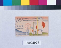
|
[生活民俗 / Lifestyle and Folk Custom] 第十二回国際オリムピック大会開催東京市決定記念市営自動車乗車券半券 |
東京市電気局 | 昭和前期 20世紀 | |
| 00002977 | |||||
| 588 |
|
[生活民俗 / Lifestyle and Folk Custom] 凧版木 Kite Printing Block |
昭和期 20世紀 | ||
| 00002978 | |||||
| 589 |
|
[生活民俗 / Lifestyle and Folk Custom] 凧版木 Kite Printing Block |
昭和期 20世紀 | ||
| 00002979 | |||||
| 590 |
|
[生活民俗 / Lifestyle and Folk Custom] 凧版木 Kite Printing Block |
昭和期 20世紀 | ||
| 00002980 | |||||
| 591 |
|
[生活民俗 / Lifestyle and Folk Custom] 凧版木 Kite Printing Block |
昭和期 20世紀 | ||
| 00002981 | |||||
| 592 |
|
[生活民俗 / Lifestyle and Folk Custom] 凧版木 Kite Printing Block |
昭和期 20世紀 | ||
| 00002982 | |||||
| 593 |
|
[生活民俗 / Lifestyle and Folk Custom] 凧版木 Kite Printing Block |
昭和期 20世紀 | ||
| 00002983 | |||||
| 594 |
|
[生活民俗 / Lifestyle and Folk Custom] 凧版木 Kite Printing Block |
昭和期 20世紀 | ||
| 00002984 | |||||
| 595 |
|
[生活民俗 / Lifestyle and Folk Custom] 凧版木 Kite Printing Block |
昭和期 20世紀 | ||
| 00002985 | |||||
| 596 |
|
[生活民俗 / Lifestyle and Folk Custom] 凧版木 Kite Printing Block |
昭和期 20世紀 | ||
| 00002986 | |||||
| 597 |
|
[生活民俗 / Lifestyle and Folk Custom] 凧版木 Kite Printing Block |
昭和期 20世紀 | ||
| 00002987 | |||||
| 598 |
|
[生活民俗 / Lifestyle and Folk Custom] 凧版木 Kite Printing Block |
昭和期 20世紀 | ||
| 00002988 | |||||
| 599 |
|
[生活民俗 / Lifestyle and Folk Custom] 凧版木 Kite Printing Block |
昭和期 20世紀 | ||
| 00002989 | |||||
| 600 |
|
[生活民俗 / Lifestyle and Folk Custom] 凧版木 Kite Printing Block |
昭和期 20世紀 | ||
| 00002990 | |||||