| 1 |  | 99200310-99200334 | 改正区郡東京切絵図
Area Map of the Revised Wards and Districts of Tokyo | 小林安信/編輯人 | 明治前期 明治13年2月 1880 19世紀 | 49.5cm x 34.9cm |
| 2 | | 99200310 | 麹町区 其一(改正区郡東京切絵図)
Kōjimachiku, Part 1 (Area Map of the Revised Wards and Districts of Tokyo) | 小林安信/編輯人 | 明治前期 明治13年2月 1880 19世紀 | 49.5cm x 34.9cm |
| 3 |  | 99200311 | 麹町区 其二(改正区郡東京切絵図)
Kōjimachiku, Part 2 (Area Map of the Revised Wards and Districts of Tokyo) | 小林安信/編輯人 | 明治前期 明治13年2月 1880 19世紀 | 49.7cm x 35.3cm |
| 4 | 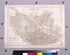 | 99200312 | 神田区(改正区郡東京切絵図)
Kandaku (Area Map of the Revised Wards and Districts of Tokyo) | 小林安信/編輯人 | 明治前期 明治13年2月 1880 19世紀 | 35.5cm x 49.9cm |
| 5 | 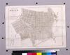 | 99200313 | 日本橋区(改正区郡東京切絵図)
Nihombashiku (Area Map of the Revised Wards and Districts of Tokyo) | 小林安信/編輯人 | 明治前期 明治13年2月 1880 19世紀 | 35.4cm x 49.3cm |
| 6 | 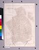 | 99200314 | 京橋区(改正区郡東京切絵図)
Kyōbashiku (Area Map of the Revised Wards and Districts of Tokyo) | 小林安信/編輯人 | 明治前期 明治13年2月 1880 19世紀 | 49.9cm x 35.3cm |
| 7 | 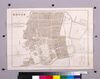 | 99200315 | 芝区 其一(改正区郡東京切絵図)
Shibaku, Part 1 (Area Map of the Revised Wards and Districts of Tokyo) | 小林安信/編輯人 | 明治前期 明治13年2月 1880 19世紀 | 35.4cm x 49.3cm |
| 8 | 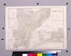 | 99200316 | 芝区 其二(改正区郡東京切絵図)
Shibaku, Part 2 (Area Map of the Revised Wards and Districts of Tokyo) | 小林安信/編輯人 | 明治前期 明治13年2月 1880 19世紀 | 35.3cm x 49.7cm |
| 9 | 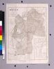 | 99200317 | 麻布区 (改正区郡東京切絵図)
Azabuku (Area Map of the Revised Wards and Districts of Tokyo) | 小林安信/編輯人 | 明治前期 明治13年2月 1880 19世紀 | 50.0cm x 35.1cm |
| 10 | 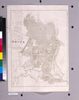 | 99200318 | 赤坂区(改正区郡東京切絵図)
Akasakaku (Area Map of the Revised Wards and Districts of Tokyo) | 小林安信/編輯人 | 明治前期 明治13年2月 1880 19世紀 | 49.5cm x 35.0cm |
| 11 | 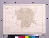 | 99200319 | 四谷区(改正区郡東京切絵図)
Yotsuyaku (Area Map of the Revised Wards and Districts of Tokyo) | 小林安信/編輯人 | 明治前期 明治13年2月 1880 19世紀 | 34.7cm x 49.5cm |
| 12 | 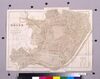 | 99200320 | 牛込区(改正区郡東京切絵図)
Ushigomeku (Area Map of the Revised Wards and Districts of Tokyo) | 小林安信/編輯人 | 明治前期 明治13年2月 1880 19世紀 | 37.5cm x 49.3cm |
| 13 | 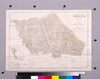 | 99200321 | 小石川区 其一(改正区郡東京切絵図)
Koishikawaku, Part 1 (Area Map of the Revised Wards and Districts of Tokyo) | 小林安信/編輯人 | 明治前期 明治13年2月 1880 19世紀 | 35.1cm x 49.3cm |
| 14 | 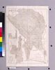 | 99200322 | 小石川区 其二(改正区郡東京切絵図)
Koishikawaku, Part 2 (Area Map of the Revised Wards and Districts of Tokyo) | 小林安信/編輯人 | 明治前期 明治13年2月 1880 19世紀 | 49.7cm x 35.0cm |
| 15 | 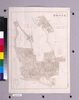 | 99200323 | 本郷区 其一(改正区郡東京切絵図)
Hongōku, Part 1 (Area Map of the Revised Wards and Districts of Tokyo) | 小林安信/編輯 | 明治前期 明治13年2月 1880 19世紀 | 49.7cm x 35.2cm |
| 16 | 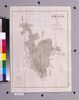 | 99200324 | 本郷区 其二(改正区郡東京切絵図)
Hongōku, Part 2 (Area Map of the Revised Wards and Districts of Tokyo) | 小林安信/編輯人 | 明治前期 明治13年2月 1880 19世紀 | 49.3cm x 34.9cm |
| 17 | 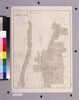 | 99200325 | 下谷区 其一(改正区郡東京切絵図)
Shitayaku, Part 1 (Area Map of the Revised Wards and Districts of Tokyo) | 小林安信/編輯人 | 明治前期 明治13年2月 1880 19世紀 | 49.6cm x 34.9cm |
| 18 | 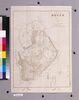 | 99200326 | 下谷区 其二(改正区郡東京切絵図)
Shitayaku, Part 2 (Area Map of the Revised Wards and Districts of Tokyo) | 小林安信/編輯人 | 明治前期 明治13年2月 1880 19世紀 | 49.7cm x 34.9cm |
| 19 | 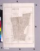 | 99200327 | 浅草区 其一(改正区郡東京切絵図)
Asakusaku, Part 1 (Area Map of the Revised Wards and Districts of Tokyo) | 小林安信/編輯人 | 明治前期 明治13年2月 1880 19世紀 | 49.7cm x 35.0cm |
| 20 | 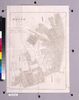 | 99200328 | 浅草区 其二(改正区郡東京切絵図)
Asakusaku, Part 2 (Area Map of the Revised Wards and Districts of Tokyo) | 小林安信/編輯人 | 明治前期 明治13年2月 1880 19世紀 | 49.6cm x 35.8cm |
| 21 | 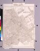 | 99200329 | 本所区(改正区郡東京切絵図)
Honjoku (Area Map of the Revised Wards and Districts of Tokyo) | 小林安信/編輯人 | 明治前期 明治13年2月 1880 19世紀 | 50.5cm x 36.1cm |
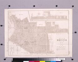
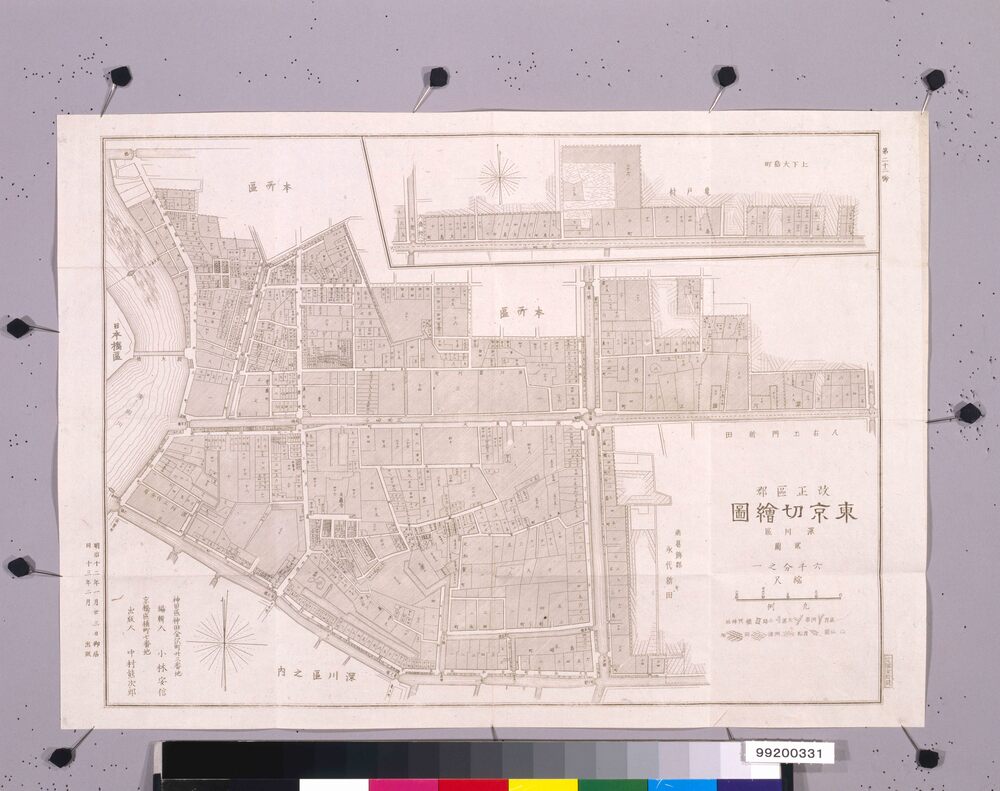
| 22 | 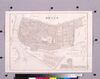 | 99200330 | 深川区 其一(改正区郡東京切絵図)
Fukagawaku, Part 1 (Area Map of the Revised Wards and Districts of Tokyo) | 小林安信/編輯人 | 明治前期 明治13年2月 1880 19世紀 | 35.0cm x 49.6cm |
| 23 | 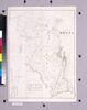 | 99200332 | 荏原 東多摩両郡全図(改正区郡東京切絵図)
Complete Map of Ebaragun and Higashitamagun (Area Map of the Revised Wards and Districts of Tokyo) | 小林安信/編輯人 | 明治前期 明治13年2月 1880 19世紀 | 49.7cm x 35.4cm |
| 24 | 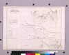 | 99200333 | 南北豊島両郡全図(改正区郡東京切絵図)
Complete Map of Minamitoshimagun and Kitatoshimagun (Area Map of the Revised Wards and Districts of Tokyo) | 小林安信/編輯人 | 明治前期 明治13年2月 1880 19世紀 | 35.6cm x 51.0cm |
| 25 | 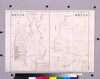 | 99200334 | 南足立 南葛飾両郡全図(改正区郡東京切絵図)
Complete Map of Minamiadachigun and Minamikatsushikagun (Area Map of the Revised Wards and Districts of Tokyo) | 小林安信/編輯人 | 明治前期 明治13年2月 1880 19世紀 | 35.4cm x 50.7cm |