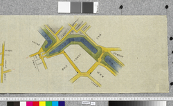
| 1 | 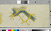 | 18200042 | 赤坂喰違より水道橋まで仮御番所并〆切矢来場所絵図
Pictorial Map of the Locations of Temporary Guard Stations and Closing Palisades from Akasaka Kuichigai to the Suidobashi Bridge | | 江戸末期 天保10~14年 1839~1843 19世紀 | 42cm x 451.0cm |
| 2 |  | 18200043 | 赤坂喰違仮御番所 壱(赤坂喰違より水道橋まで仮御番所并〆切矢来場所絵図)
Akasaka Kuichigai Temporary Guard Station 1 (Pictorial Map of the Locations of Temporary Guard Stations and Closing Palisades from Akasaka Kuichigai to the Suidobashi Bridge) | | 江戸末期 天保10~14年 1839~1843 19世紀 | |
| 3 |  | 18200044 | 桜田新シ橋〆切絵図 弐(赤坂喰違より水道橋まで仮御番所并〆切矢来場所絵図)
Pictorial Map of the Sakurada Atarashibashi Bridge Closed Area 2 (Pictorial Map of the Locations of Temporary Guard Stations and Closing Palisades from Akasaka Kuichigai to the Suidobashi Bridge) | | 江戸末期 天保10~14年 1839~1843 19世紀 | |
| 4 | 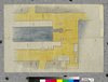 | 18200045 | 土橋仮御番所絵図 三(赤坂喰違より水道橋まで仮御番所并〆切矢来場所絵図)
Pictorial Map of the Dobashi Temporary Guard Station 3 (Pictorial Map of the Locations of Temporary Guard Stations and Closing Palisades from Akasaka Kuichigai to the Suidobashi Bridge) | | 江戸末期 天保10~14年 1839~1843 19世紀 | |
| 5 | 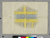 | 18200046 | 芝難波橋〆切絵図 四(赤坂喰違より水道橋まで仮御番所并〆切矢来場所絵図)
Pictorial Map of the Shiba Naniwabashi Bridge Closed Area 4 (Pictorial Map of the Locations of Temporary Guard Stations and Closing Palisades from Akasaka Kuichigai to the Suidobashi Bridge) | | 江戸末期 天保10~14年 1839~1843 19世紀 | |
| 6 | 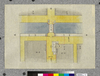 | 18200047 | 芝口仮御番所絵図 五(赤坂喰違より水道橋まで仮御番所并〆切矢来場所絵図)
Pictorial Map of the Shibaguchi Temporary Guard Station 5 (Pictorial Map of the Locations of Temporary Guard Stations and Closing Palisades from Akasaka Kuichigai to the Suidobashi Bridge) | | 江戸末期 天保10~14年 1839~1843 19世紀 | |
| 7 | 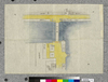 | 18200048 | 永代橋〆切絵図 六(赤坂喰違より水道橋まで仮御番所并〆切矢来場所絵図)
Pictorial Map of the Eitaibashi Bridge Closed Area 6 (Pictorial Map of the Locations of Temporary Guard Stations and Closing Palisades from Akasaka Kuichigai to the Suidobashi Bridge) | | 江戸末期 天保10~14年 1839~1843 19世紀 | |
| 8 | 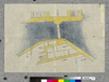 | 18200049 | 新大橋 七(赤坂喰違より水道橋まで仮御番所并〆切矢来場所絵図)
Shin-Ohashi Bridge 7 (Pictorial Map of the Locations of Temporary Guard Stations and Closing Palisades from Akasaka Kuichigai to the Suidobashi Bridge) | | 江戸末期 天保10~14年 1839~1843 19世紀 | |
| 9 | 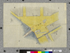 | 18200050 | 両国橋絵図 八(赤坂喰違より水道橋まで仮御番所并〆切矢来場所絵図)
Pictorial Map of the Ryogokubashi Bridge 8 (Pictorial Map of the Locations of Temporary Guard Stations and Closing Palisades from Akasaka Kuichigai to the Suidobashi Bridge) | | 江戸末期 天保10~14年 1839~1843 19世紀 | |
| 10 | 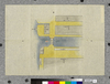 | 18200051 | 柳橋〆切絵図 九(赤坂喰違より水道橋まで仮御番所并〆切矢来場所絵図)
Pictorial Map of the Yanagibashi Bridge Closed Area 9 (Pictorial Map of the Locations of Temporary Guard Stations and Closing Palisades from Akasaka Kuichigai to the Suidobashi Bridge) | | 江戸末期 天保10~14年 1839~1843 19世紀 | |
| 11 | 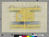 | 18200052 | 新シ橋仮御番所絵図 十(赤坂喰違より水道橋まで仮御番所并〆切矢来場所絵図
Pictorial Map of the Atarashibashi Bridge Temporary Guard Station 10 (Pictorial Map of the Locations of Temporary Guard Stations and Closing Palisades from Akasaka Kuichigai to the Suidobashi Bridge | | 江戸末期 天保10~14年 1839~1843 19世紀 | |
| 12 | 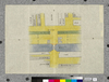 | 18200053 | 和泉橋〆切絵図 十壱(赤坂喰違より水道橋まで仮御番所并〆切矢来場所絵図)
Pictorial Map of the Izumibashi Bridge Closed Area 11 (Pictorial Map of the Locations of Temporary Guard Stations and Closing Palisades from Akasaka Kuichigai to the Suidobashi Bridge) | | 江戸末期 天保10~14年 1839~1843 19世紀 | |
| 13 | 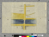 | 18200054 | 昌平橋〆切絵図 十弐(赤坂喰違より水道橋まで仮御番所并〆切矢来場所絵図)
Pictorial Map of the Shoheibashi Bridge Closed Area 12 (Pictorial Map of the Locations of Temporary Guard Stations and Closing Palisades from Akasaka Kuichigai to the Suidobashi Bridge) | | 江戸末期 天保10~14年 1839~1843 19世紀 | |
| 14 | 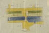 | 18200055 | 水道橋 十三(赤坂喰違より水道橋まで仮御番所并〆切矢来場所絵図)
Suidobashi Bridge 13 (Pictorial Map of the Locations of Temporary Guard Stations and Closing Palisades from Akasaka Kuichigai to the Suidobashi Bridge) | | 江戸末期 天保10~14年 1839~1843 19世紀 | |
| 15 | 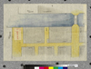 | 18200056 | 芝金杉橋御番所絵図 外(赤坂喰違より水道橋まで仮御番所并〆切矢来場所絵図)
Pictorial Map of the Shiba Kanasugibashi Bridge Guard Station (from a Different Source) (Pictorial Map of the Locations of Temporary Guard Stations and Closing Palisades from Akasaka Kuichigai to the Suidobashi Bridge) | | 江戸末期 天保10~14年 1839~1843 19世紀 | |
| 16 | 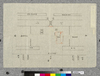 | 18200057 | 柳原新橋仮番所絵図(赤坂喰違より水道橋まで仮御番所并〆切矢来場所絵図)
Pictorial Map of the Yanagihara Shimbashi Bridge Temporary Guard Station (Pictorial Map of the Locations of Temporary Guard Stations and Closing Palisades from Akasaka Kuichigai to the Suidobashi Bridge) | | 江戸末期 天保10~14年 1839~1843 19世紀 | |